After the First Fleet’s arrival in 1788, British authorities claimed sovereignty over the entirety of eastern Australia. They justified this claim under the doctrine of terra nullius (meaning “land belonging to nobody”). As a result, the lower north shore became part of Crown property, and the government promptly began dividing up parcels of land for settlement and development
In the 40 years between the 1790s and 1830s, land in the areas now known as North Sydney, Neutral Bay, and Kirribilli was allocated through colonial land grants. These grants were designed to promote the establishment of European settlements and to stimulate both agricultural and industrial development in the region.

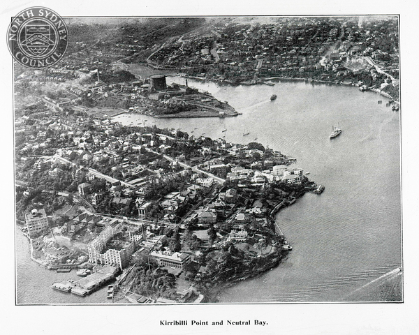
During this period, much of the lower north shore was consolidated into large private estates; however, when granting or selling land, the government reserved corridors for public roads and thoroughfares. High Street in North Sydney was one such corridor, linking the harbour (Careening Cove and Neutral Harbour) with inland settlements.
The north shore’s rugged topography and nutrient-poor soils, comprising Hawkesbury Sandstone and Narrabeen Group formations, made it less accessible and less suitable for agriculture than the more fertile, gently sloping terrain south of Sydney Harbour. As a result, early settlers concentrated on maritime industries at Careening Cove, where boatbuilding and repair facilities were established
As the lower north shore developed throughout the nineteenth century, large private estates were progressively subdivided into smaller residential lots. This process, particularly evident from the late 1850s and 1860s, facilitated the construction of cottages, terraces, and villas, and contributed to the area’s urban growth.


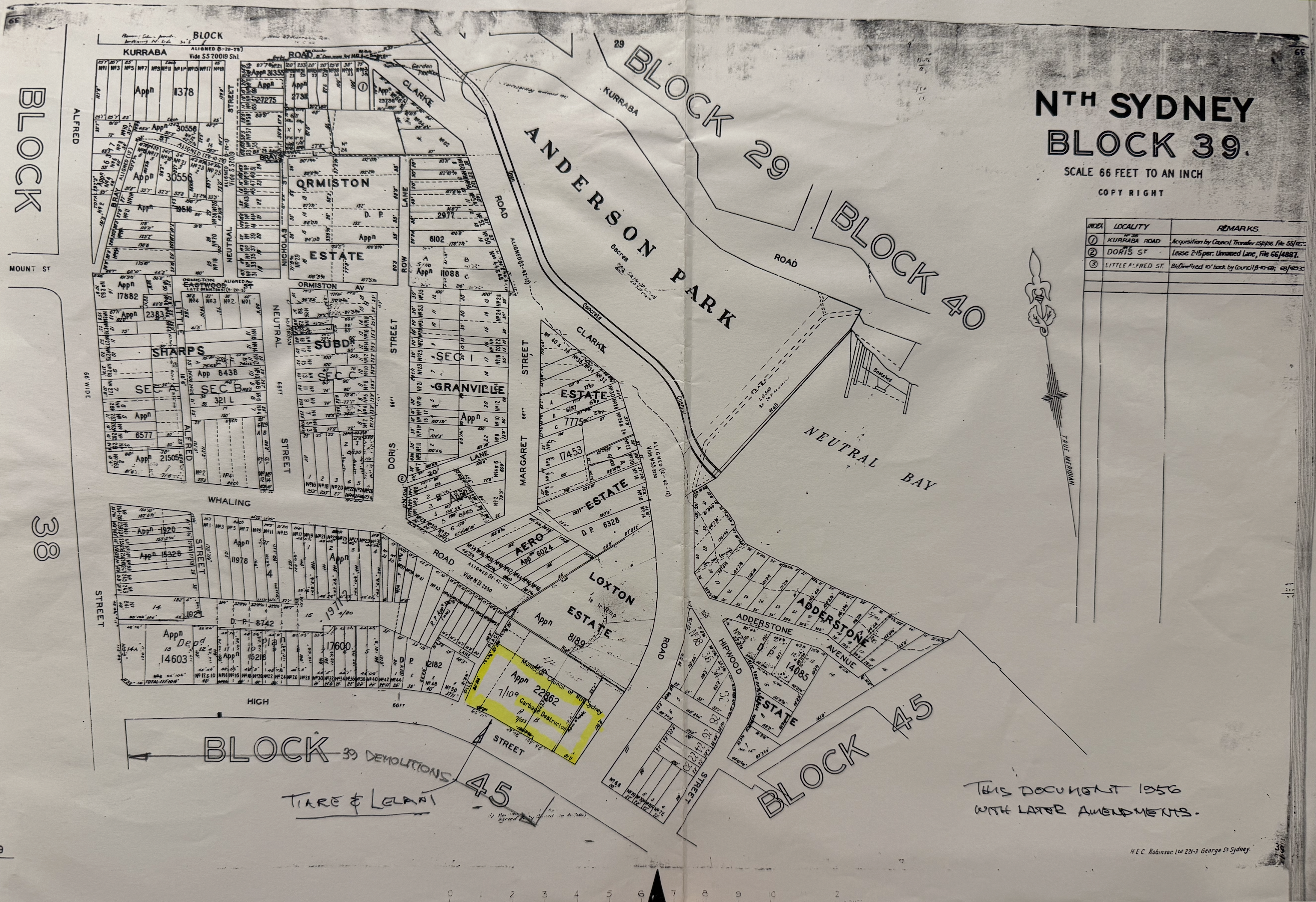
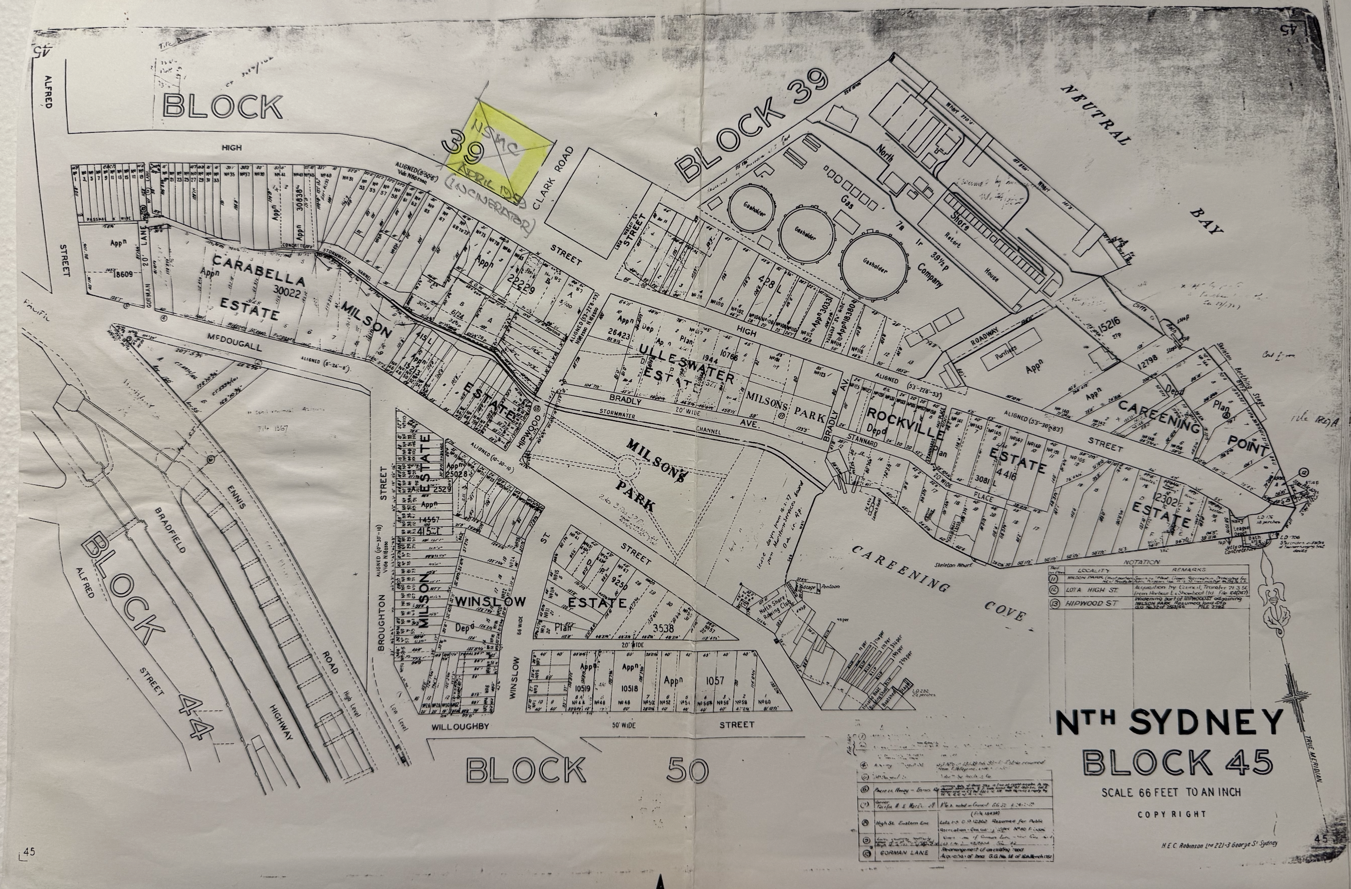
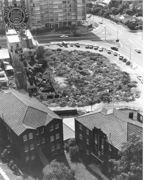
Photographs from the 1920s clearly show a large chimney at the corner of High Street and Clark Road. Although the Neutral Bay Gasworks-operated by the North Shore Gas Company from 1876 was situated only a few hundred metres away at Neutral Harbour, this chimney was not associated with gas production.

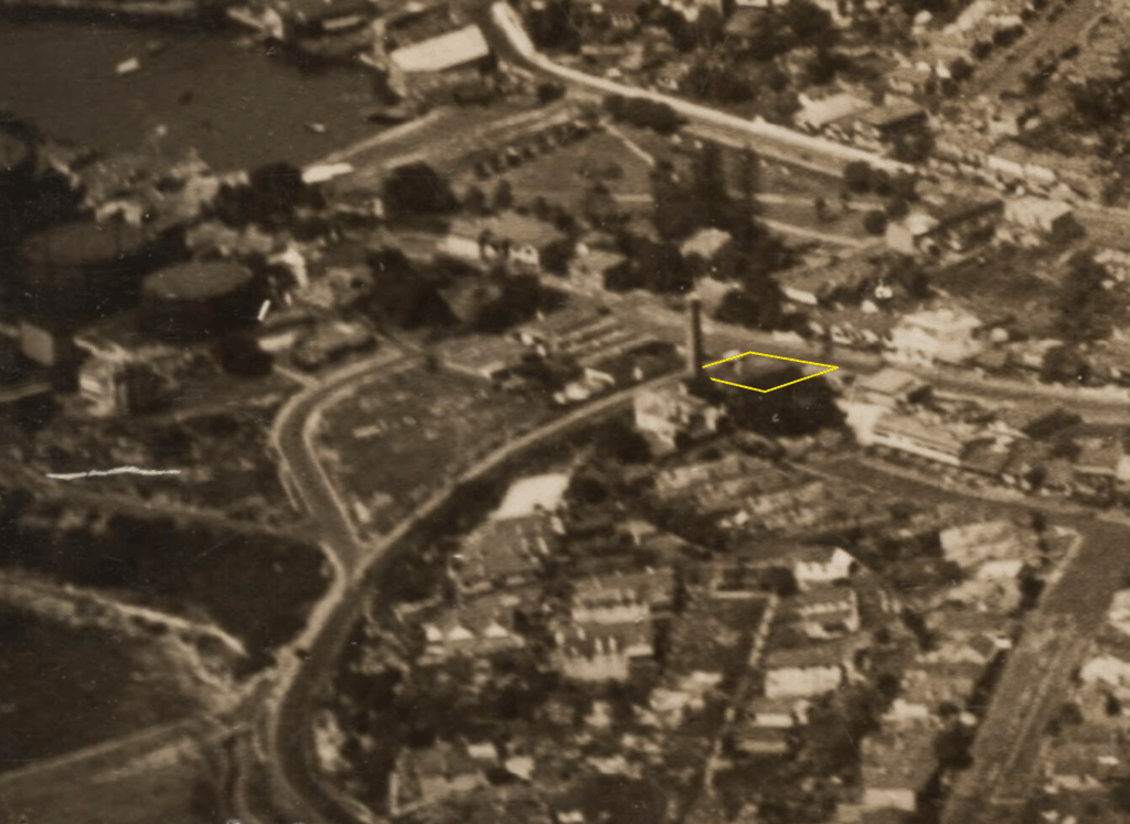

This corner block was the site of the North Sydney Municipality Council (NSMC) Depot. The tall smoke stack was an incinerator. It caused significant air pollution and put the public’s health at risk. By 1959 it had been decommissioned and demolished.
The Creation of Lelani
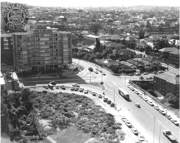
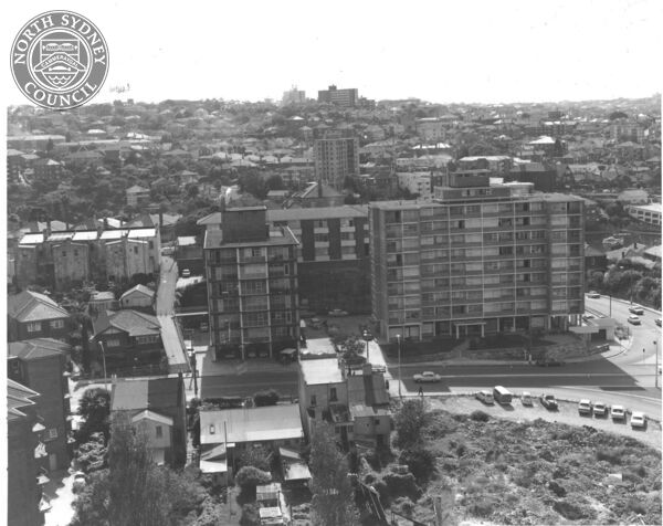
In the early 1960’s one developer built three distinct residential towers adjacent to each other, on seperate titles. These were:
- 59 Whaling Road (Morea)
- 52 High Street (Tiare)
- 54 High Street (Lelani)
Notably, all three building names are derived from exotic terms inspired by flowers.
Lelani was the last of three flats to be built. On 17th October 1961 North Sydney Municipality Council approved a development application lodged by High Street Investments Pty Ltd.
The project was titled ‘Block of 104 Bachelor Flats’ and was designed by architects McCauley, Conran & Associates of 62 Alfred St, Milsons Point. This firm still exits but has since been renamed MCA Architects (https://www.mca-architects.com.au)


The edifice reached completion in 1963; however, occupancy of the ground floor commenced in 1962 while construction of the upper stories was still in progress.
The building was given the name Lelani, a Hawaiian-inspired term meaning “heavenly flower” Given the cultural context Sydney in the 1960s, the name “Lelani” was likely selected for its exotic and fashionable connotations, reflecting the mid-century Australian trend of adopting Polynesian-inspired names to evoke a sense of modernity and allure, rather than for its precise linguistic or cultural accuracy.
Lelani at 54 High Street exemplifies mid-century modernist architecture, characterised by its clean lines, functional design, large windows, and minimal ornamentation-hallmarks of the International Style that became prevalent in Sydney’s residential developments during the early 1960s.
Lelani’s large glass foyer with rockery settings inside and out was considered avant-garde in early 1960s Sydney, directly reflecting the influence of the Modern Movement. This design borrowed ideas from leading international architects and trends, especially European Modernism and the work of figures like Harry Seidler, who brought principles such as openness, integration with nature, and transparency to Sydney’s residential architecture. The adoption of these features at Lelani demonstrates how local architects adapted and reinterpreted modernist concepts-such as expansive glazing and natural materials-to suit Australian conditions and postwar cultural shifts toward modernity, communal living, and a break from tradition

For the first 12 years between its construction in 1962 to its sale in 1974, Lelani was a privately owned serviced apartment building. It operated as a short term accommodation for business travellers as well as a number of workers at the nearby HMAS Platypus.
Each unit had its own milk hatch so residents could securely receive deliveries of newspapers, milk and bread without the need for direct contact or entry into the unit. These service hatches were eventually filled in due to the draft they created posing a fire risk, however their outline is still visible on the outside of each unit.
The four commercial spaces on the ground floor have been occupied by a variety of tenants including supermarkets and mining investment firms.
In 1965, the ground floor commercial space was home to the André Fourment Art Gallery. André was a French born artist who immigrated to New Caledonia after World War II and later to Australia. Below is a news clipping from 1965 promoting an art exhibition.

At the André Fourment Art Gallery
(54 High Street, North Sydney), the originals of 15 Old Master paintings by French, English, and Italian masters are currently on display. The gallery is open Wednesday to Sunday, from 1:30 a.m. to 8:30 p.m.
Conversion to Strata Title
In 1974, Lelani was converted to strata title, making it one of the earlier examples of this form of property ownership in New South Wales. The advertisement below dates from the initial public offering of the studio apartments. Notably, marketing for the units extended as far as Port Moresby, indicating that the developer sought to position the units as urban residences for business travellers.
Details of the conversion to strata title are scarce but fortunately long term resident [name removed] has written an insightful account.
On the original builder he wrote
“…As I knew it, the building was created in 1960/61 from property previously owned by North Sydney Council and was built as serviced apartments similar to 52 High street and Morea, the property behind, having been built, I believe, by the same builder, a Mr. Little, and was managed by Peter Hill real estate agents.”
He went on to write
“The Strata Plan was created in 1974 and sold off as individual units with a title deed. The boundaries were determined legally on plans but were impossible to police as 52 High street uses 54’s driveway to access their four car parking spots on the left hand side of the driveway and the building behind, one with the staircase, some of their people use our property to access High street”
Speaking on the purchase process and early days of the strata plan he had this to say:
“David Hooker, the son of LJ and one time owner of ‘Dragon Boat Races’ and ‘Waterwings’ along with Tony Allen, then the owner of Ben Boyd real estate, and, with them both trading as Purple Holdings, set up an office in what is now the convenience store and sold me my unit in 1975.”
“David Hooker was the proprietor of lots 105/106 in the early days of the Strata Plan and, having signed the by-laws himself allocating the number of unit entitlements as 4 and 3, made heated attempts to have them reduced and we, that was Jim Harvie of Harvie Strata Management, and myself as
elected secretary, on behalf of the body corporate refused this demand.”
“David Hooker made it very difficult for us and, among other things, he refused to let us gain access to the roof through the penthouse to inspect it for maintenance purposes.”
Speaking on the controversial exclusive use areas he recalled the following:
“It was David Hooker himself who signed the by-laws on or
about September 1974 and allocated the owner of lots 105/106 full use and enjoyment of the common property penthouse and of the common property underground garage.”
On attempts to revoke the unjust by-laws he had this to say:
“As a result of the difficulties with D.H., and on the advice of a solicitor, we set out to have the by-laws declared illegal as when they were signed in 1974, only one unit in the strata plan had
been sold, not 50% as, I think, was required then by law. Before going to court, Jim Harvie sought the advice of Gary Bugden, writer of strata law books, and his advice was that the by-
laws were legal as Purple Holdings were not the initial owners of the building. The buildings were originally owned by a company called MEPC and they sold it to a company within themselves; called MSRL, and I assume that Purple Holdings were the owners of about 99% of the units and were eligible to create the by-laws.”
On the topic of parking he had this to say:
“When the property was created as serviced apartments in 1960/61, all the residents of the 8th floor and some of them on the 7th floor as well as the occupants of the shop and the two other
commercial properties, then Contax and Pan Public Relations, owners of lots 107 & 108? on the ground floor and they both owned the southern half of the undercover car parking space but not the access to those spots. The northern half of these car parking spots were originality allocated to the owner of lots 105 & 106 but were opened up to all by the by-laws of 1974 on a first come basis and, incidentally, I used to park undercover near the laundry sometimes but was advised by the owner of lot 108, Pan P.R., many years ago that they had paid $1 to have the legal right
of the access to their property. In recent years, as a result of the by-laws, Tony Perry (owner of Lot 105/106 prior to 2014) did not ‘own’ these parking spots so therefore had nothing to give away.“
And finally,
“To complicate things a little, a fire in North Sydney Council offices destroyed documents and our strata management company in Berry street, North Sydney, criminally set fire to a property in Sydney also destroying records.”

Contax Pty Ltd had an office at 54 High Street in the 1980’s.

In the mid-1980s, mining startup Lachlan Resources N.L. was headquartered on the ground floor at Lelani. Lachlan Resources was eventually listed on the ASX under the ticker code LLR.

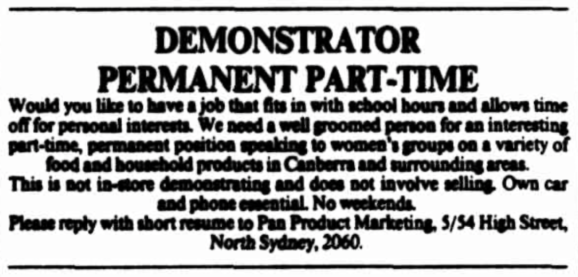
One of the commercial suites at Lelani in the 1980’s was the office of P.A.N. Public Relations AKA Pan Product Marketing.